For the last few decades, scientists have kept trying to learn more about tornadoes and about the way they are formed, in an attempt to be able to predict them and their movements. Prior to the 1950’s, one could only detect a tornado if he saw it. Weather offices often knew about these tornadoes only after they were finished. Thanks to the radar designed for weather purposes though, places could get warnings that severe weather was nearby in advance. In 1950, the first warnings of tornadoes were issued, and starting from 1953 it was known that the hook echoes could be associated with a tornado. Since a radar signature could be recognized by meteorologists, the thunderstorms which could make tornadoes were detected when they were miles away.
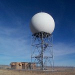
Radar
These days, the majority of the countries have weather radar networks in place, which are essential for detection of tornadoes and other weather events. The US uses Doppler weather radars, which will measure both the radial direction and the speed of a storm’s winds, so they are capable of noticing if there is rotation taking place in a storm even if they’re over 100 miles away at the time. The farther away that the storm is from the radar, the less areas are observed, so the resolution and the amount of data might not be sufficient. The method is far from perfect right now, since some tornadoes can form at a higher speed than the radar is capable of completing a scan. Tornado formation could happen very quickly just as a severe thunderstorm turned severe from a regular thunderstorm.
Storm Spotting
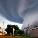
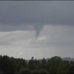
Starting from the 1970’s, storm spotters started to be trained, which could be used to spot certain features that are part of storms, which could result in tornadoes, high speed winds and severe hail. These storm spotters that were trained where deputies, firefighters, normal people, storm chasers and ambulance drivers, as well as civil defense personnel. If a rotating or non-rotating wall cloud is observed, that area or right near the wall cloud is the are to take notice of funnel formation. In addition, any hail observed is an indicator of a strong updraft that is a crucial ingredient for tornado formation. Crisp thunderstorm clouds with sharp contrasting features are other observational elements that indicate a stronger thunderstorm present or developing.